This has been updated to reflect the current implementation of the roadway.
Safety Goals for Alameda Portion
The primary objective of these modifications to this section of Alameda was to prioritize the safety of pedestrians, cyclists, and residents. Consequently, the following approaches were established:
- Significant Reduction in Crosswalk Lengths
- Creation of Bike Lanes with a 1-2 Foot Traffic Safety Buffer
- Widening of Sidewalks
- Provide safety for cyclists, pedestrians, residents
- Change ‘Expressway’ perspective to reflect a residential feel
- Address speeding traffic and high accident rate
- Enhanced Safety for Residential Driveways
- Creating an ambience of a calmer, slower roadway
Furthermore, Alameda motorists would benefit from the presence of a central 2-way turn lane, thereby facilitating safer left turns onto and off Alameda. This 2-way center turn lane is very successfully in place on Santa Cruz Ave south of the “Y” intersection with Alameda.

Summary of Concerns/Issues:
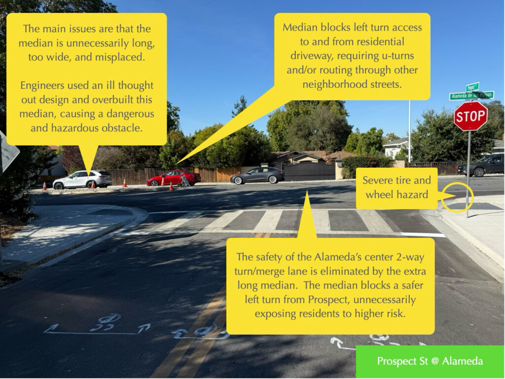
The implementation of changes on Alameda between Prospect St. and Liberty Park Ave has unfortunately created a situation where our safety goals are not being met; or, stated differently, that our safety goals were compromised in favor of an ill thought out median and its placement.
Please view the illustrated photos further below.
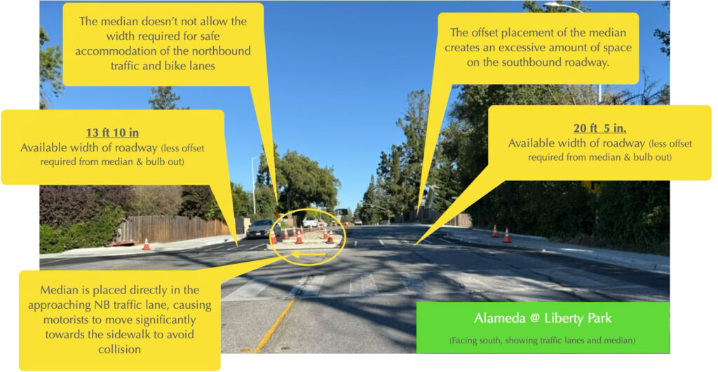
- The majority of the median is placed directly in the NB traffic lane; that is, it is offset towards the sidewalk by approximately 8 feet. Causing motorists to steer significantly to the right, towards cyclists and sidewalk.
- Instead of having a 5’ bike lane and a 1 or 2 foot traffic buffer to separate traffic and the bike lane, cyclists are now confined by traffic shifting right and a sidewalk bulb out on the other side that has vertical hard curbs.
- The median, in the northbound direction, doesn’t provide the width needed to safely accommodate the 1 traffic lane, bike lane, and the safety offset needed to keep traffic away from the median and curb.
- Prospect residents are blocked from making safer and easier left turns to enter Alameda traffic.
- Alameda resident is blocked from making left turns in to or out of their driveway.
- The new median is wider than agreed. The Project’s Safety Task Force had agreed on 10′ traffic lanes and that should would included this median.
- The southbound – west side – roadway at the median presents an opposing issue. It is almost a full traffic lane wider than the northbound width, significantly wider than necessary. This excessive width of the SB roadway creates the impression of a wide-open roadway, encouraging motorists to drive at full speed ahead, which contradicts our safety objectives. Also a safe risk for Prospect St.
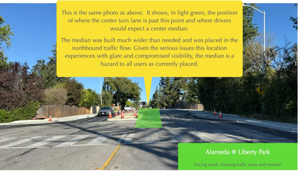
- The median’s design and location, situated on the crest of a hill, ignores the visibility challenges that exist here on Alameda. Glare from the sun and headlights significantly impair a motorist’s ability to see the median. Furthermore, its placement is unexpected, as most drivers do not anticipate a median to abruptly obstruct a substantial portion of their normal travel lane.
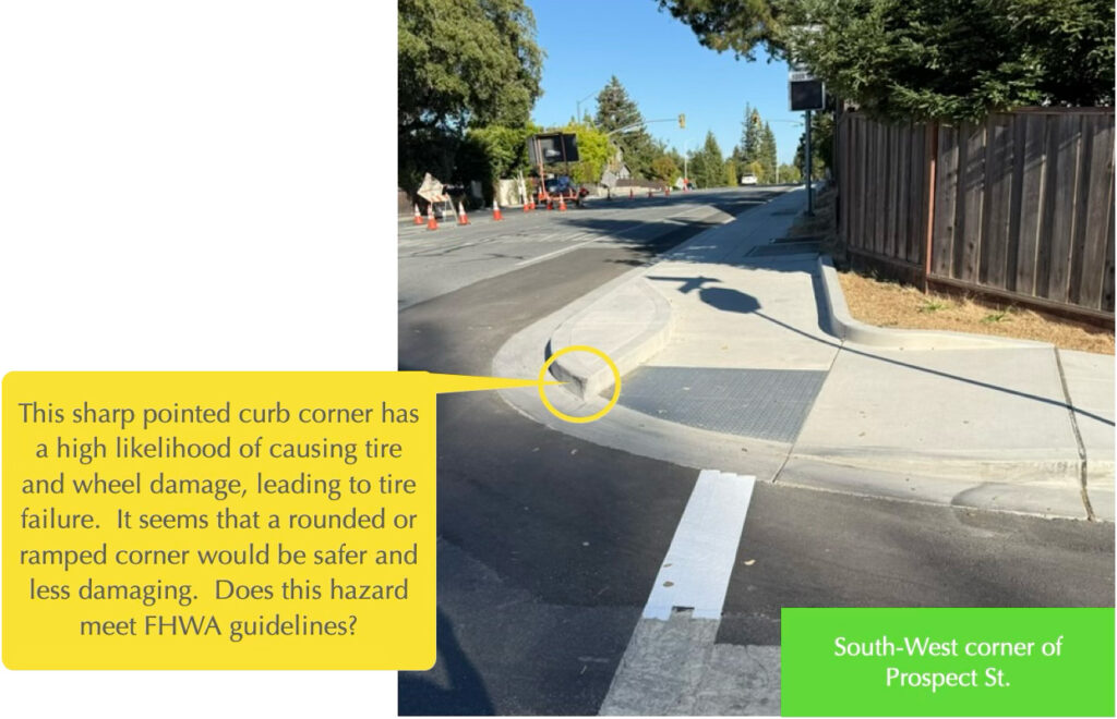
For Prospect traffic, the issues include a curb corner hazard and prohibition of using the safer center 2-way turn/merge lane as it is fully blocked by the excessively long median.
Below, a view looking south on Alameda at the Liberty Park intersection. On the right, notice the huge amount of roadway width allocated for just a single lane of traffic and a bike lane. Compare that to the left side of the median where not enough width to safely accommodate the same single traffic and bike lane.
The image below shows where the center turn/merge lane is for all of Alameda – excepting this displaced-offset median. Imagine if a slightly narrower median was placed inline with how most motorists would expect it to be.
This sharp pointed curb shown below is a serious hazard and will cause wheel and tire failures. It should be changed to allow a ramped or otherwise shape to remove the tire damage risk. This is a corridor wide problem with recent DPW corner curbs as this issue occurs at several locations, including at Avy and Palo Alto Way.
Why is Liberty Park Intersection Challenging?
From a safety engineering perspective, the intersection of Alameda and Liberty Park has several challenges:
- The intersection and crosswalk are on the crest of a hill — this means very limited visibility; for example, crosswalk is not visible until a driver is just seconds from crossing it.
- The intersection has significant issues with sunlight and shadows
- The rising and setting sun is inline with the road creating a blinding glare both directions
- Night visibility is low – rain causes additional glare and obscures the roadway
- This intersection is used by families and school kids that attend several nearby schools
Visibility Problems to the Max!
Consider the sightline and visibility issues: (See Visibility Issues at Liberty Park) When obstacles are placed in the travel lane, they are invisible from any distance other than just at the hill crest. This leaves motorists just a few seconds to veer towards the sidewalk and bike lane to avoid hitting the extended median.


A few views of the approach to the Liberty Park crosswalk. top-left to bot-rt: Southbound just past Avy (evening); Southbound morning from Avy; Southbound morning from Avy; Southbound morning from Avy; Northbound at night, just past Sharon; Northbound at evening, just past Sharon; Note, crosswalk can not be seen until just a few seconds before crossing it.
From a safety perspective, the following are being ignored by the County Plan for this location:
- Motorists expect a consistent road configuration. Engineers generally avoid, road swerves, traffic lane configuration changes, and obstacles in line with traffic paths, etc. In this case, County fails all of these guidelines, effectively hiding these lane modifications and obstacles on the crest of the hill. Drivers traveling in this section may not be aware and may suddenly react to the unusual configuration to avoid striking the median – that puts everyone at risk.
- Shorter crosswalks – DPW slightly shortened the crosswalk in their Feb 2024 design modification; however, the bulb outs used are minimal, making this crosswalk longer than needed.
- Pedestrian Safety – Several advantages of parking spaces, are that parking provides a safety buffer between people and the traffic lanes. Additionally, parking allocation narrows the perceived width of the roadway to encourage calmer – slower driving speeds. Our corridor has a terrible and continued history of cars crashing past sidewalk and into properties, with accidents right at and around this Liberty Park intersection– let’s not ignore the need to have the extra safety buffer a parking area provides. This is not an argument for parking, so if even parking is removed, we should keep that space as a greenery space to preserve the buffer distance between pedestrians from vehicles. Note: A high volume of kids use this area.
- Road way consistency and motorist awareness — The plan implements a design that fails to incorporate the geography of the road, Alameda at this location is on a crest of the hill, the sunlight blinding glare, and the other lighting issues of brightness and shadows. Raised medians in the traffic path, lane shifts, longer crosswalk all on a ‘blind crest’ of the hill creates a high risk to all users. Motorists have just seconds of visibility before they have to react. These NB motorists must abruptly react and veer towards the bike lane and sidewalk to avoid hitting the raised median, put cyclists and pedestrians at great risk.
- Residential access safety
- For Prospect residents: County Plan increases danger of turn left on to Alameda due to swerving traffic, no access to center turn/merge lane, and area sightline issues.
- Alameda Residents: At least one driveway is blocked and would require a U-Turn or similar to access.
- Cyclists safety diminished and are exposed to high risk issues:
- Unexpected swerving traffic towards cyclists
- The bike safety buffer is removed in this configuration
- Issues with line of sight and glare issues add to driver distractions and increased risk to cyclists
- Having a roadway with random lane widths and offsets, including random bike lane configurations all on this 300′ hill crest creates confusion and distractions that raise risk.
Your feedback, concerns, and questions welcome!!
Please add your thoughts, concerns, feedback, and questions by using the Reply comment form below. All comments go through an approval step, meant to keep spam comments in check. Please be constructive with your comments and respectful.
If you would like to write County directly, please use this email link to address an email to assist in adding email addresses. You can also leave a comment below
Updated March 2024 – Safety@Safer4Us.com
It seems that County is ignoring the hill that obscures the location of Liberty Park. People that live here know the lighting and glare issues. We also know the speed issues along this roadway. This plan especially ought to take into consideration Prospect St residents as it seems to make it less safe for them to turn from or into their street: They have had safety concerns for years and now it seems the new plan will only add risks for them.
It appears that making this section of Alameda the same as what the rest of the Alameda will be, has many safety advantages and will address the County plan’s problem of veering traffic suddenly towards the sidewalk and bike lane.
Thanks for the information and making it available.
I have looked at the County plan and the Safe4Us plan. As a car driver and as a bicyclist I like the Safe4Us plan and I don’t like County plan. I don’t like raised areas, the double left turn lane or the NB narrowing after Prospect. As a car driver this is complicated and confusing. As a bicyclist I don’t want the car drivers around me to be confused. The complexity makes it more likely that cars will come into the bike lanes by mistake. I expect that the safety aspects of the County plan for slowing traffic will be more than undone by the unsafe actions drivers who are confused. The Safe4Us plan seems simple, straightforward and I expect it is less expensive. Why make things more complicated?